Description: This brand new sprint area will be the ultimate spectator event for 2013. The terrain is quite similar to The Slump (used for the final World Cup Stage) and was formed by a huge natural land slide near the Tuki Tuki river. You will find very strange/intricate but very fast open-farmland contour detail sprinkled with rocks and other point features. The entire race [mass start by classes] will be visible to spectators from the clifftops above, so get a good spot to watch the elite grades battle it out head to head!
Category Archives: Orienteering

New Zealand – STB – Stage 4 Napier Central
Description: A new map introduced to STB in 2012, and an instant favourite amongst the urban sprinters. The map covers a vast majority of the ‘Art Deco Capital of the World’ that is Napier city. You’ll need that 6th (or even 7th gear) for this stage, the terrain is super fast urban style with some areas of park and intricate building detail.

New Zealand – STB – Stage 3 Kaiwaka
Again, no pictures! Will have to see what I can borrow from elsewhere…
Description: Another brand new sprint map for 2013. This is a very unique and tricky terrain type never seen before in Sprint the Bay (or in NZ to our knowledge). Set in the riverbed of the meandering TukiTuki river with unusual contour and vegetation detail, Kaiwaka will challenge STBers’ physical and technical abilities to the max after the beginning urban stages.

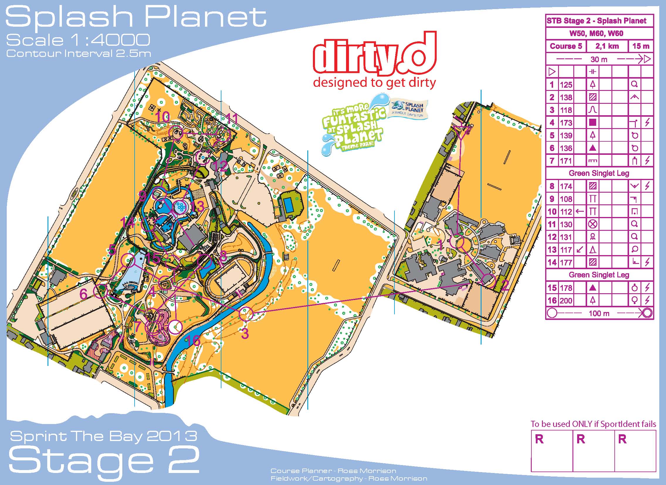
New Zealand – STB – Stage 2 Splash Planet
Description: A brand new map in New Zealand’s biggest water park. This will be a highlight of STB 2013 for both competitors and spectators. Terrain consists of intricate park detail, and building areas, you will face very fast but technical courses and expect to get wet!
In between the morning and evening races, Phillip and Tim added a small extension to the monitor stand in order to add another two monitors in the vertical position. These gave enough room to get some splits up for everyone.
Sadly, I have no pictures from this day, probably because this was a fast and furious setup since we couldn’t get into the park until after closing time. We also had to carry all of the equipment about 100 feet from the trailer to the event center. Even with lots of hands, things ran behind, and the starts were delayed 30 minutes.
New Zealand – STB – Stage 1 Woodford
Sprint the Bay – six events in three days.
From the STB website – Description: the first stage will be held on an updated Woodford map. This map is part of the Woodford Iona map first used for the NZ champs in 2011. It consists of very technical building detail, school grounds and farm type terrain. Parts of the map are very steep making it very physically demanding and also allowing for difficult route choice legs.
Setup was easier with the reduced number of monitors, and it was nice to have the start and finish within meters of each other. However, the reduction of the monitors to two proved to be somewhat inadequate for the number of results needing to be displayed.

New Zealand – Rest day in Hastings
Well, it was sort of a rest day. A leisurely start to the day, followed by unloading and reloading the trailer with a reduced amount of equipment. I also organized the leftover maps by day and by course. Continue reading
New Zealand – Race 7 – The Slump
Last day of the Oceania Carnival, World Cup races, and there were three separate races today. First up was the World Cup Prologue, followed by the Oceania Carnival mass start race, with the World Cup Chasing start event last.

New Zealand – Race 6 – Smedley
Back in Hastings, so these events were the responsibility of the Hawkes Bay Orienteering Club (HBOC), with Jane and Phillip are the event coordinators.
Another day with temps near 80, and it was apparent that lots of thought had been given to the event center layout for the day, since the setup was done in a way that allowed the small bits of forest to be easily accessible for maximum shade cover for the participants.


Since I was going to take another late start, I indulged in a couple of sausage sandwiches for a mid-morning meal. I surprised then when I asked at 9 AM if the sausage were ready. They weren’t, but I was set up soon after. These concession stands were interesting in that they were all parent run, with the profits going to their children’s travel fund.

Linda Kohn, Rick Worner, and me – Team USA.

USA – Wild Country.

The Finish.

Callum, finishing strong.


Catherine worked in the download tent all day. Callum downloading.

Terrain description: Gully spur farmland with scattered totara, denser around some of the gullies and streambed surrounded by some impassable cliffs and native trees of variable runnability.
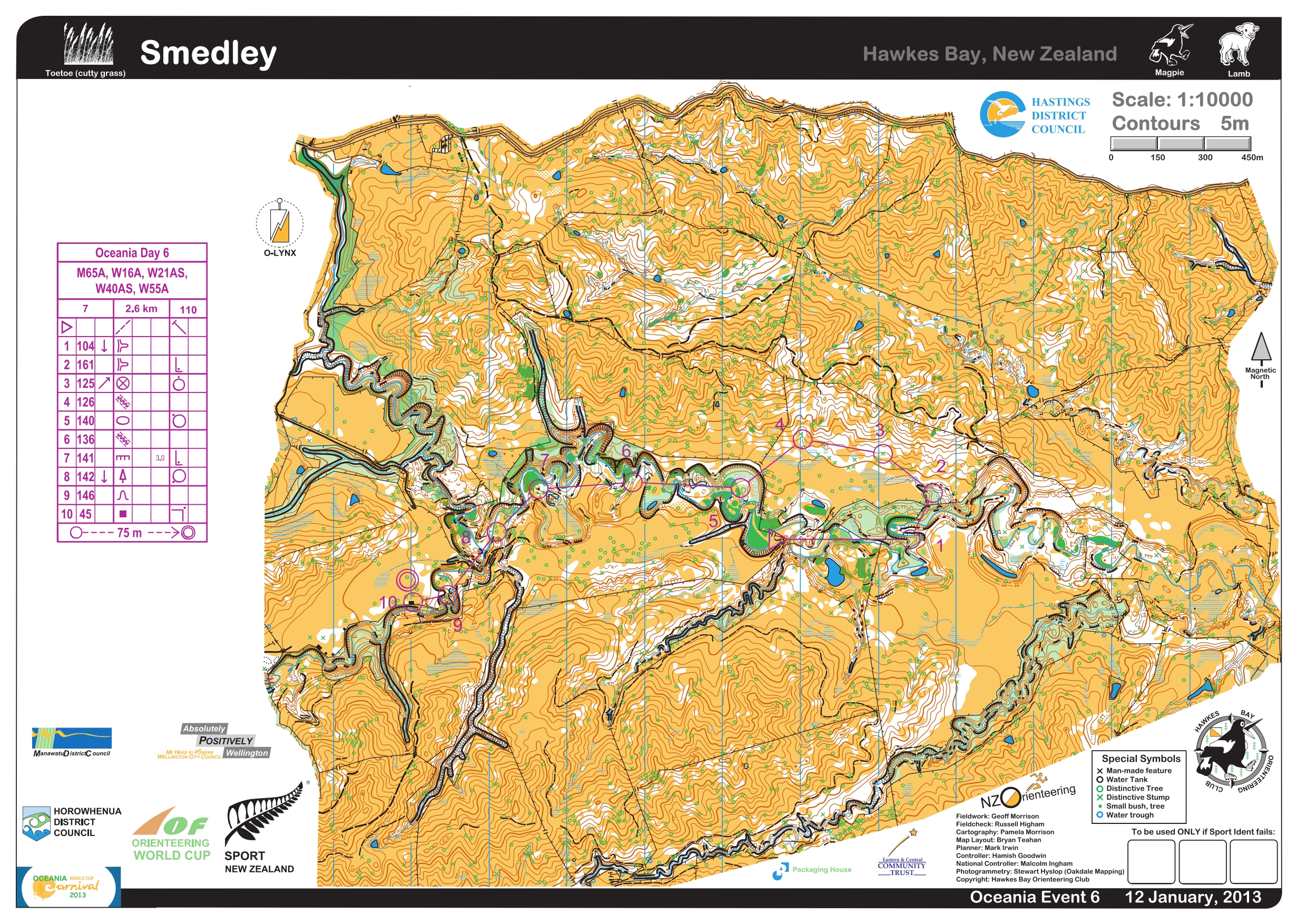
I loved this map and course! I just wish I had done it more justice. I totally butchered the first control, getting disoriented when I came through the light green. I made matters worse when I didn’t recognize the fence junction where I was, and there was only the one in the whole area on the map.
As usual, I settled in a bit after that with only a little hiccup to 2, and the benefit of some elephant tracks from 2-3-4. I almost did something crazy from 4-5 when I ventured partway down the uncrossable cliff to see if it really was uncrossable. It was, and it was a bit scary getting myself back to safe ground. I kept telling myself that Jane and Phillip didn’t deserve having to deal with me getting injured by doing something as stupid as trying to go down a cliff.
Used the creek as much as possible to finish up the course, especially after visiting the swamp near 7.
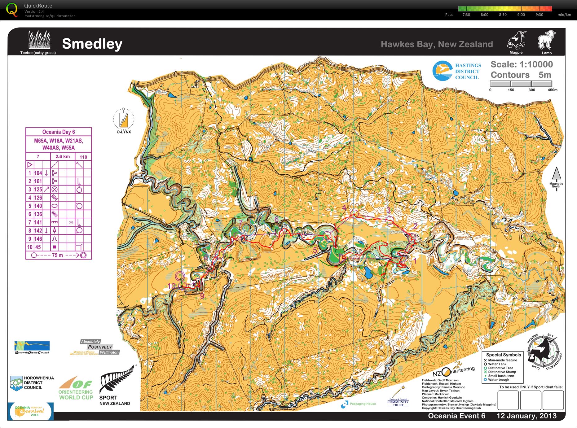
Race stats: 2.6 km, 110 m climb, 10 controls
Garmin distance: 3.14 miles with 104 m climb
Place: 19/27
Time: 1:25:18
Time lost: 10:45 minutes
Time per km: 32:43
Waited around for controls after everything was loaded up. Took the time to explore the HBOC caravan more closely – I want one!

And, the totara near the finish.

New Zealand – Oceania Relay
Today was the Oceania Relay, which I had no plans to participate in. Not that I probably couldn’t have been talked into being on a relay team, but I was glad that I wasn’t on one. However, I was interested in doing something in addition to the results duties, so I offered to put out the three radio controls and two repeaters (on the hill above each control). After the event, I picked up the units in the reverse order. Thoroughly enjoyed the walk around the pastures, and even hiking up to the top of the hills. I could tell that I was fitter than I was a week ago even.

Terrain description: Generally rolling open farmland with isolated trees and good visibility, interspersed with hills, marsh, streams, gullies, scrub, native bush, pine forest, rock and taipos (rocky spires).
The repeater above 109.

The superfluous repeater between 109 (the control had been on the antler like wood pile) and the repeater above. One bar is all that is needed! Get over it!

The view towards the 87 hill.

Some sheep for Lailah. There were lots of sheep.


The repeater above 87. Retrieving this one later on was a little scary because the wind was blowing pretty hard.

The event center in the distance from the 87 hill.

Exited the hill from the back way.

After packing up, it was back up the highway to Hastings to stay for the duration.
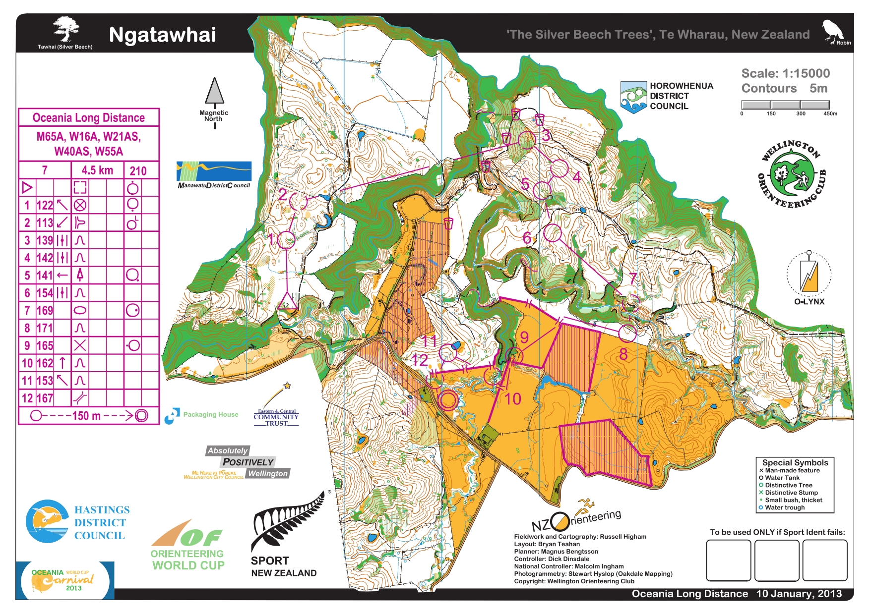
New Zealand – Race 5 – Ngatawhai
Oceania Carnival Long Distance race today. Not many pictures for some reason.
 (Courtesy of P. Herries.)
The wind from yesterday had died down, but the sun was pretty hot. The same routine as the other days – set up, hang out, go out on a course.
Terrain description: Generally fast open mature pine forest, with some patches of native Manuka trees. Several extremely step and gnarly gorges are crossing the area.
Today, I got a bit confused on what my start time was, missing it by 10 minutes, even after getting a ride from Jane to close to the start. Embarrassed myself by thinking I was just a minute late, even running up to the next line. Oops! It took them another two minutes to realize what had happened, and so I was pulled out, in the nicest possible way, and assigned the last start of the day.
Turned out to be a good mistake, because I got to chat with some other W55s, including Bronwyn for the first time. Just before Bronwyn’s start, she discovered that the sole of her shoe was partway off. So, another woman offered up her wrist band, and I pulled off the headband, and we tied her shoe together and off she went. Headband to the rescue again!
Then it was my turn. This terrain felt familiar, so I was a bit ticked off at myself when I messed up the first control. Settled in after that, but took the really long way to #3 and a bit of an adventure in the scruffy part to #7. Had not had enough to eat that day, and I bonked and stumbled my way around to the finish.
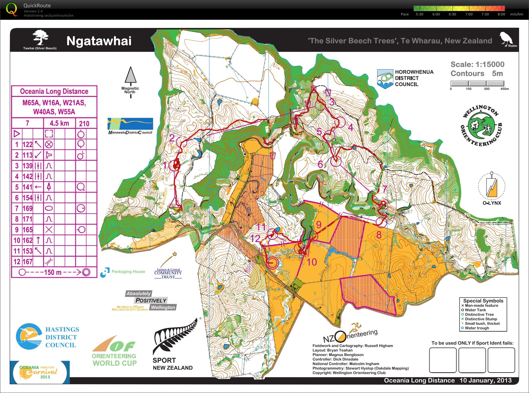
Race stats: 4.5 km, 210 m climb, 12 controls
Garmin distance: 4.73 miles with 275 m climb
Place: 22/27
Time: 1:58:36
Time lost: 14:19 minutes
Time per km: 26:00
Jumped into the pool at the motel when I got back. Refreshing!